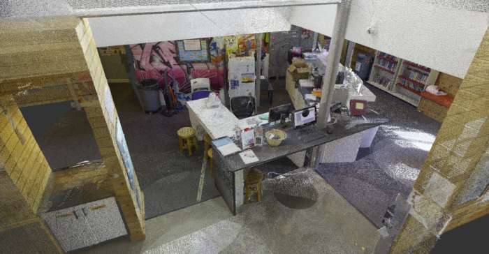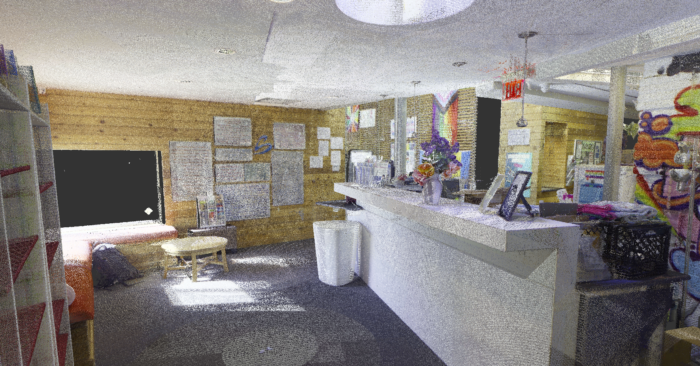
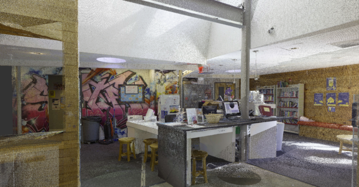
Finally! Heathe Ball called me (Vanessa Murphy) to meet him on location to experience my very first laser scan. We met at a local outreach program to scan their lobby. The program officials were redesigning the reception area, planning to install a new desk, and opening up the room to create a less congested space.
After meeting with the program head to understand their goals, it quickly became clear why such a seemingly small project required Rogue Visual Design’s precision. The renovation area was compact, and they aimed to conserve as much existing material as possible during demolition. Four structural columns—one of which penetrated the center of the existing desk—posed a challenge, along with in-floor electrical boxes that needed to be considered in the design. Accurate scan data would ensure these critical elements were accounted for in the new layout.
Setting Up the Scanner
Heathe introduced me to the Leica RTC360, a high-speed 3D laser scanner designed for capturing detailed spatial data. As he set it up, he walked me through the process, showing how to mount it on the tripod—much simpler than the one I use for my DSLR. The scanner features multiple onboard cameras and an infrared laser capable of capturing highly accurate 3D measurements.
One of the most crucial steps was determining scan placement. We used masking tape as a visual guide:
- A single piece marked the regular height scan locations.
- A split piece in an “L” shape indicated an additional scan at a lower tripod height to capture finer details, such as the in-floor electrical boxes.
Scanner placement follows two key principles:
- Line of Sight: The scanner must have a clear view of all surfaces to measure them accurately. If it can’t “see” something, it can’t capture it.
- Registration Overlap: Each scan needs sufficient overlap with the next so the software can align them into a unified point cloud.
This was a relatively simple environment, which made it an ideal space to learn the basics. In more complex locations, however, scanner placement becomes significantly more critical. The knowledge and experience of a skilled LiDAR specialist are essential to ensure complete coverage and prevent data gaps in intricate or obstructed spaces.
With our layout set, we were ready to scan.
Capturing the Scan Data
Heathe walked me through the scanner’s settings before initiating the first scan. With the press of a button, the Leica RTC360 began capturing the environment.
So how does it work? The scanner emits an infrared laser pulse onto a rotating mirror, essentially painting the surroundings with light. As the scanner head rotates, the laser sweeps across objects, measuring the distance based on how long the light takes to reflect back. This technique, known as LiDAR (Light Detection and Ranging), records both horizontal and vertical measurements at an astounding 2 million points per second. This impressive speed is one of the RTC360’s key advantages, allowing it to collect a vast amount of detailed data faster than most scanners on the market.
In fact, it took me longer to write this paragraph than it took the scanner to complete its first 360-degree sweep of the area—in under two minutes. During the first rotation, the scanner captured 35 million precise measurements. The second rotation recorded full-dome HDR (High Dynamic Range) images, enriching the dataset with high-quality visual details.
Real-Time Data Transmission
Heathe moved the scanner to the next location, and this time, he let me start the scan. While waiting, he showed me how the scan data instantly transmitted to his tablet as soon as each scan was completed.
This immediate feedback was fascinating. The tablet allowed us to:
✓ Check for coverage gaps in real time
✓ Verify data alignment on-site
✓ Ensure no rescans were needed
This capability is invaluable—it saves time and eliminates the risk of returning to the office only to find missing or inaccurate data. Each completed scan smoothly merged with the previous one, forming a growing 3D point cloud right before our eyes.
Hands-On Experience
Now, it was my turn to handle both the scanner and the tablet. I positioned the scanner at the next marked location, double-checked the setup with Heathe, and started the scan.
This time, we had to carefully step out of the laser’s path as it rotated. Any objects or people caught in the scan would appear as unwanted data points in the final model, which could require extra cleanup or manual editing later in the process. As the scan ran, Heathe taught me how to register each new scan with the previous one on the tablet. When he moved the scanner again, he left me to handle the data verification and alignment—giving me full control over the process.
We repeated this sequence for every location until we completed all scans at regular height. Then, we lowered the tripod for the close-to-ground detail scans, ensuring that elements like the electrical boxes and other objects were fully documented. Each of these scans was registered to its corresponding standard-height scan, completing the dataset.
From setup to final teardown, the entire process took just under an hour—far quicker than I had expected for such a detailed capture.
Addressing Photography & HDR Challenges
As a photographer, one thing immediately caught my attention. The lobby had three large windows allowing in a significant amount of light. I wondered how the scanner managed exposure control. Would the HDR photos overexpose highlights and cause data loss?
To my surprise, the RTC360’s advanced HDR imaging system handled this effortlessly—no need for any manual lighting adjustments. The scanner automatically balanced exposure, ensuring clear images even in high-contrast environments. Heathe showed me how these HDR images could be used to enhance the scan, making text and signage on walls more readable in the final dataset.
I was amazed at how effortlessly photography and LiDAR technology worked together to create both accurate measurements and visually rich data.
Final Thoughts
Seeing LiDAR in action firsthand changed my perspective on scanning technology. What initially seemed like a complex, high-tech process quickly became an intuitive and efficient workflow. The ability to capture, verify, and process data in real-time is an absolute game-changer for renovation projects, especially in tight spaces with intricate details.
It’s equally valuable in historical preservation work, where fragile surfaces must be documented without contact, and in industrial settings where equipment layout or structural changes require extreme accuracy.
While this environment was relatively simple, I gained a deeper appreciation for how critical a LiDAR specialist’s knowledge becomes in more complex locations.
I can’t wait to see what’s next in my LiDAR learning journey!
-Vanessa Murphy – Digital Marketig Manager for Rogue Visual Design